
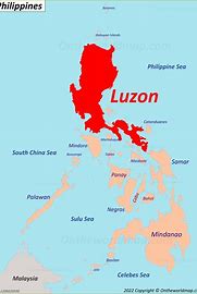
In a project that has raised eyebrows and sparked discussions, Deng Yuanqing, a Chinese national, along with two Filipino drivers, Jojo Besa and Jayson Amado Fernandez, embarked on a 35-day journey across Luzon. Their mission? To map out 120 critical sites, including military camps, ports, and energy infrastructure, spanning at least 18 provinces.
The journey began on December 13, 2024, and involved meticulous planning and execution. The team travelled at high speeds, covering vast distances daily while avoiding government checkpoints due to heightened security during the election period. Their route included significant locations such as the 5th Infantry Division in Isabela and the Camilo Osias Naval Base in Cagayan.
The team was equipped with advanced technology and captured detailed data that could not be easily obtained through satellite imagery. This raised concerns among Philippine authorities, who described the activity as “military targeting.” The project ended abruptly on January 17, 2025, when the trio was arrested in Makati City during a routine stop to back up their collected data.
The incident has sparked debates about national security and the implications of foreign involvement in surveying critical infrastructure. While the Chinese embassy in Manila dismissed the allegations as baseless, Philippine authorities continue investigating the matter, emphasizing the potential risks the collected data poses.
This case reminds us of the importance of vigilance in safeguarding a nation’s critical assets, especially in an era when technology can be both a tool for progress and a potential threat.